Jul 17 2008
CLEANING THE UPPER TWO MILES: A SHORT HISTORY
The United States Environmental Protection Agency (EPA) summarizes some of the river’s history and acknowledges the major challenge facing the river in Berkshire County:
The Housatonic River is located in a predominantly rural area of western Massachusetts, where farming was the main occupation from colonial settlement through the late 1800s. As with most rivers, the onset of the industrial revolution in the late 1800s brought manufacturing to the banks of the Housatonic River, in Pittsfield, MA. General Electric (GE) began its operations in its present location in 1903. Three manufacturing divisions have operated at the GE facility (Transformer, Ordnance, and Plastics).
The 254-acre GE plant in Pittsfield has historically been the major handler of polychlorinated biphenyls (PCBs) in western Massachusetts, and is the only known source of PCBs found in the Housatonic River sediments and floodplain soils in Massachusetts. Although GE performed many functions at the Pittsfield facility throughout the years, the activities of the Transformer Division, including the construction and repair of electrical transformers using dielectric fluids, some of which contained PCBs (primarily Aroclors 1254 and 1260), were one likely significant source of PCB contamination. According to GE’s reports, from 1932 through 1977, releases of PCBs reached the waste and storm water systems associated with the facility and were subsequently conveyed to the East Branch of the Housatonic River and to Silver Lake.
During the 1940s, efforts to straighten the Pittsfield reach of the Housatonic River by the City of Pittsfield and the U.S. Army Corps of Engineers (USACE) resulted in 11 former oxbows being isolated from the river channel. The oxbows were filled with material that was later discovered to contain PCBs and other hazardous substances.
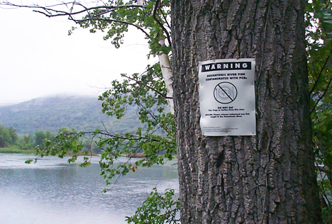
A fish consumption advisory for the Housatonic River was issued by the Massachusetts Department of Public Health (MADPH) in 1982 from Dalton, MA, to the Connecticut border as a result of the PCB contamination in the river sediments and fish tissue. It was later amended to include frogs and turtles. The State of Connecticut also posted a fish consumption advisory for most of the Connecticut section of the river in 1977. In addition, in 1999, MADPH issued a waterfowl consumption advisory from Pittsfield to Great Barrington due to PCB concentrations in wood ducks and mallards collected by the Environmental Protection Agency (EPA) from the river. Concerns expressed by local residents regarding possible health effects resulting from exposure to PCB contamination are being investigated by the MADPH.
While the two miles downstream from the facility have historically been channelized, the river’s course is relatively unaffected (with the exception of the numerous dams downstream) in areas south of Pittsfield. The approximately 10 miles of river from the confluence of the East and West Branches of the Housatonic to the headwaters of Woods Pond in Lenox are bordered by extensive floodplains (up to 3,000 feet wide), ranges from 45 to 100 feet in width, and has a meandering pattern with numerous oxbows and backwaters. Woods Pond, a shallow 56-acre impoundment, was formed by the construction of a dam in the late 1800s.
The land use/ownership of the floodplain properties include private and residential, agricultural, recreational (such as canoeing, fishing, and hunting), wildlife management areas and parks.
GE for many years successfully claimed that there were only 39,000 pounds of PCBs in the Housatonic – and even the August 1988 EPA Facility Assessment for the GE Facility used those numbers (III-29). Thanks to the efforts of the late Ed Bates, a manager at GE’s Power Transformer Division, the Housatonic River Initiative was able to more accurately estimate and argue that in excess of a million and a half pounds of PCBs migrated from the GE plant into the River. A coalition of environmental groups and former GE workers has spent more than 30 years fighting for an effective cleanup of contaminated neighborhoods, Silver Lake, and the Housatonic.

On October 17, 1999, the EPA, the Massachusetts Department of Environmental Protection, the Connecticut Department of Environmental Protection, and General Electric reached a comprehensive cleanup agreement covering the GE plant, off-site properties in Pittsfield, and the Housatonic River.
From the EPA summary of the Consent Decree:
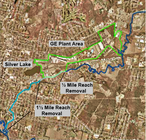
Housatonic River – Upper ½ Mile Reach (Newell Street Bridge to the Lyman Street Bridge):
Objective: to achieve a clean-up that is protective of human health and the environment within the Upper ½ Mile Reach and to prevent further downstream migration of contaminants …
Housatonic River – Next 1 ½ Mile Reach from the Lyman Street Bridge to the Confluence of the East and West Branches (includes sediments and riverbanks):
Objective: to achieve a clean-up that is protective of human health and the environment within the 1 ½ Mile Reach and to prevent downstream migration of contaminants.
While many in the Berkshire community supported the Consent Decree and regarded it as a necessary if imperfect compromise, the Housatonic River Initiative (HRI) intervened and challenged the decision in United States District Court. HRI complained that PCB-contaminated sediments in the River and contaminated soil in the riverbank and floodplain were being removed and landfilled rather than being treated with innovative technologies.
HRI cited EPA’s enabling legislation, the Comprehensive Environmental Response, Compensation, and Liability Act (CERCLA), commonly known as Superfund, specifically Section 9621(b) which states:
Remedial actions in which treatment which permanently and significantly reduces the volume, toxicity, or mobility of the hazardous substances, pollutants, and contaminants is a principal element, are to be preferred over remedial action not involving such treatment. The offsite transport and disposal of hazardous or contaminated materials without such treatment should be the least favored alternative remedial action where practicable treatment technologies are available.
HRI argued that the cleanup would not adequately prevent remaining underground sources of PCBs and upstream contamination from recontaminating the river. It contested the decisions to rely on extensive capping of the river bottom with geotextiles and to dump large amounts of PCB-contaminated material in GE-owned landfills adjacent to the Allendale Elementary School.
Under pressure from local politicians, the business community, and the federal and state governments, in April 2000, HRI concluded settlement negotiations with the EPA, the Justice Department and the States of Massachusetts and Connecticut. In return for withdrawing its intervenor motion, HRI received assurances that contaminated property owners would not be penalized, public involvement at the site would be strengthened, and that the EPA would investigate innovative remedial technologies when it came to planning a cleanup for the Rest of the River.

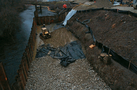
The first ½ Mile cleanup was completed in September 2002. According to the EPA Summary:
Sediment and bank excavation was performed in the following manner. Sheetpile was driven in the middle of the river channel and the flow diverted to 1⁄2 of the river channel. Sections of the river were then dewatered and the “dry” sediment removed by conventional equipment (e.g., backhoes, cranes, etc.). Restoration of the riverbed included placement of a cap containing a silty sand sorptive layer, covered by an armored layer to return the riverbed to its existing elevation and as a substrate for restoration.
Restoration included enhancing, where possible, instream and river bank habitat. During the excavation, non-aqueous phase liquid (“NAPL” or free product) was observed in sediment and in the river bank in several locations. At each of these locations, GE, under EPA oversight, removed the NAPL and NAPL-stained sediment down to a maximum depth of eleven feet, completed further bank soil excavation, and installed additional impermeable sheetpile walls to minimize the NAPL migration from the river bank.
As a result of these actions, approximately 11,800 cubic yards of sediment and 6,400 cubic yards of bank soil were removed. The majority of the material was disposed of at the GE On-Plant Consolidation Areas at the GE facility, but sediment containing free product [highly concentrated PCB-oil] were disposed of at off-site facilities.
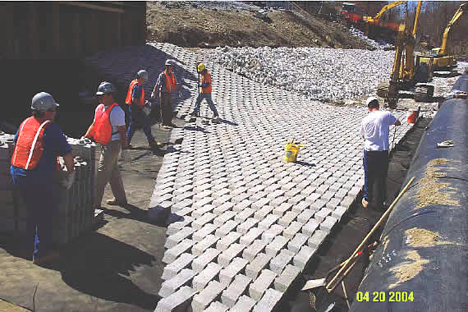
The second clean-up of the 1 1⁄2 Mile Reach was completed in 2006.According to the EPA summary:
The 1 1⁄2 Mile Reach represents a section of the East Branch of the Housatonic River between Lyman Street Bridge and the confluence of the East and West Branches of the Housatonic River. The 11⁄2 Mile Reach is located within residential, commercial, industrial and undeveloped/recreational properties. There are approximately 40 residential properties located adjacent to the Housatonic River or within the floodplain. In the 1940s, approximately 1,500 feet of this reach was re-channelized by the City of Pittsfield and the United States Army Corps of Engineers. During the re-channelization efforts, three oxbows located within the first 1,500-foot stretch of the 1.5 Mile Reach were filled in. In the first mile of the 1.5 mile reach, the riverbanks are generally steep and the floodplain is narrow. In the last half mile, the riverbanks are relatively low, resulting in a broad floodplain.
The average concentration of PCBs in the surficial sediments (0 to1 foot depth) was 21 parts per million (ppm) and the average concentration of PCBs in sediments at all depths was 29 ppm. For the riverbanks, the average concentration of PCBs in the top foot was approximately 23 ppm and the average concentration of PCBs in the top three feet was 40 ppm.
In September 2002, immediately following GE’s completion of the Upper 1⁄2-Mile Reach remediation, EPA initiated remediation activities in the 11⁄2 Mile Reach. EPA completed excavation activities in March of 2006. Restoration activities, including restoration of support areas, were substantially completed by the end of 2006.
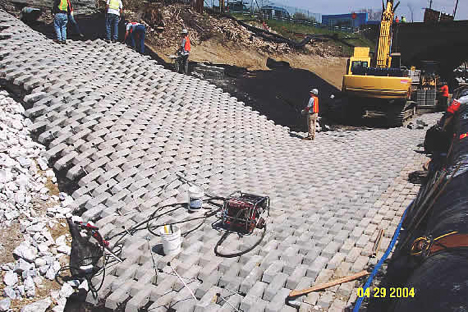
EPA performed the 1 1⁄2 Mile removal action using two “dry excavation” techniques. The first technique used was similar to the method employed by GE in the Upper 1⁄2-Mile Reach. This is the sheetpile coffer dam technique, which consisted of using sheetpile to construct individual sheetpile cells along the river. To build a cell, a sheetpile wall was installed along the centerline of the riverbed, followed by an installation of upstream and downstream sheetpile cut-off walls, which branched off the centerline sheetpile wall and extended up the riverbank. The river flow is thus diverted around the sheetpile cell, the cell is then dewatered, and the sediment and riverbank soil is removed. The cell is then backfilled with clean fill and riprap to the design grade. Next, the two cut-off walls were removed and re-installed on the opposite side of the river, thus creating the next cell to be remediated and restored. Remediation activities then proceeded downstream, with the activities alternating from one side of the river to the other. Standard excavating equipment was used to complete the sediment and soil removal and backfilling. A typical sheetpile cell was approximately 300 feet long and approximately 30 feet wide.
The second “dry excavation” technique involved the use of a gravity-fed bypass system. The bypass system consisted of a temporary river diversion dam, which was installed approximately 1,400 feet downstream from the Lyman Street Bridge, and was used to divert the river flow into two 54-inch movable High Density Polyethylene (HDPE) pipes. The pipes were placed along one side of the river channel and the riverbed sediment and riverbank soil on the other side were removed and backfilled. The sediment and soil removal and backfilling was done by using standard excavation equipment. The pipes were then moved to the remediated side of the river and the process was repeated. Additional sections of pipe were added to the two 54-inch pipes extending the system as the removal and restoration progressed downstream. The gravity bypass system was used to remediate and restore approximately 3,400 feet of the river channel to a location 400 feet downstream of the Dawes Avenue Bridge. The gravity bypass technique was used in this area because shallow bedrock prevented the use of the sheetpile coffer dam system …
In total, approximately 91,700 cubic yards (CY) of contaminated sediment and riverbank material was removed and disposed of as part of the 1.5 Mile Reach Removal Action. Approximately 7,000 CY of this material was impacted by non-aqueous phase liquids (NAPL). 50,750 CY of the contaminated material was disposed of at the GE’s On-Plant Consolidation Areas and the remainder of the contaminated material, including all of the NAPL-impacted material, was disposed of at licensed off-site disposal facilities.
The contaminated sediments and soils for the two miles of river cleanup were landfilled at two adjacent “Consolidations Areas” across from the Allendale School. This aerial image shows how close the dumps are from the school:


With the completion of the cleanup of the first two miles, the effort to save the Housatonic shifts to the Rest of the River.
And as you will see when you read about GE’s Proposal, the issues of dredging and capping and landfilling are once again at the forefront of the discussion.