Jul 17 2008
UPPER HOUSATONIC ACEC
Overview of the Upper Housatonic River ACEC Nomination
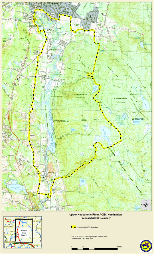
The area nominated for an ACEC covers approximately 12,280 acres in portions of four Berkshire communities – Lee, Lenox, Pittsfield, and Washington. The respective approximate acreage of the nominated area within each community is:
- Lee, 1,610 acres;
- Lenox, 3,545 acres;
- Pittsfield, 3,155 acres; and
- Washington, 3,970 acres.

Summary of Resource Highlights and Significance of Upper Housatonic River ACEC Nomination
The concentration, significance, complexity and diversity of the resources leave no doubt that the proposed area meets the ACEC threshold of regional or statewide significance. As separate resource features and as a dynamic ecosystem, the Upper Housatonic River corridor is highly significant to both the Berkshires and to the state.
- The habitat and wildlife values reflected in the extraordinary number of rare species (31), Certified and Potential Vernal Pools (44), amount of Biomap Core Habitat (4,600 acres or 37% of the area, plus another 27% of Biomap Supporting Natural Landscape), and amount of Living Waters Core Habitat and Critical Supporting Watershed (3,600 acres or 29%) are more than enough to meet any criteria for regional or statewide significance. The listed species include seven Endangered, 13 Threatened, and 11 Special Concern pursuant to the Massachusetts Endangered Species Act (MESA). There are three or portions of three separate Biomap Core Habitats within the nominated area. These three Core Habitats were delineated for six exemplary communities, 22 rare plants, two rare butterflies, one rare damselfly, three rare birds, one rare turtle, and four rare salamanders. The nominated area includes two NHESP documented natural communities that are uncommon community types across Massachusetts, an Acidic Graminoid Fen and a Level Bog. Further, the nominated area includes at least 21.5 river miles of Cold Water Fisheries, contains abundant fishery resources, is a regionally significant bird habitat and migratory corridor, and has been designated an Important Bird Area by Mass Audubon.
- Public Recreation Areas within the nominated area cover approximately 6,800 acres or over half (55%) of the nominated area. These areas include the 262-acre Mass Audubon Canoe Meadows Wildlife Sanctuary, the 818-acre George L. Darey Housatonic Valley Wildlife Management Area of the MA Division of Fisheries and Wildlife, and the adjacent 200-acre Post Farm managed by the Lenox Conservation Commission, several boat access sites, and approximately 5,520 acres of the October Mountain State Forest. The Darey WMA is one of western Massachusetts’s most heavily utilized wildlife management areas for all types of passive recreation including hunting, fishing, trapping, hiking, canoeing/kayaking, bird-watching, and wildlife viewing. The Canoe Meadows Wildlife Sanctuary contains outstanding wildlife habitat resources, and is dedicated to wildlife habitat conservation and public education; trails in the Sanctuary are used extensively by the public for passive recreation, wildlife appreciation, and group programs. October Mountain State Forest is the largest state forest in Massachusetts at approximately 16,500 acres. Approximately 5,520 acres are located within the proposed ACEC (or 45% of the total area of the proposed ACEC).
- There is a wealth of documentation of the historical and archaeological resources for the Upper Housatonic River Corridor, as well as for the greater Housatonic River Valley. The nominated area is part of the Upper Housatonic Valley National Heritage Area. Historic and archaeological resources have been documented in a Cultural Resources Assessment for the Housatonic River prepared for the General Electric Company in April, 2008. The old Lenox Train Station is listed on the State and National Register of Historic Places. There are historical and archaeological sites located within October Mountain State Forest.
A History of the Upper Housatonic River Corridor by local historian Bernard Drew was prepared for this nomination. - Cultural Areas – lands of agricultural productivity and as forest land – cover approximately 9,360 acres or 76% of the nominated area – about ¾ of the entire nominated area. The west slopes of the State Forest include 1,120 acres of designated Forest Reserves. 1830’s forest land, considered a valuable forest and habitat resource, covers approximately 3,450 acres or 28% of the nominated area. The amount of forest lands, Forest Reserves, and 1830’s forest clearly indicate the importance of these areas as part of the larger Upper Housatonic River corridor and ecosystem.
- Surface waters include approximately 12.9 miles of the Housatonic River, and portions of at least eight named tributary brooks and creeks, all highly important to the water quality, wildlife habitat, and overall resource quality of the nominated area. The area also includes several ponds, lakes and reservoirs.
- Inland wetlands cover approximately 1,445 acres or 12% of the total proposed area.
- Natural hazard areas, areas defined by 100-year flood zones or steep slopes greater than 25%, include approximately 56% of the nominated area, indicating the overall environmental sensitivity of the nominated area.

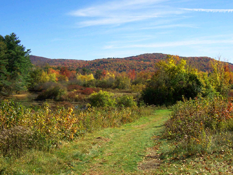
Significant Scenic Sites are located throughout the nominated area:
ACEC DOCUMENTS
You can read the entire Nomination of the Upper Housatonic River as an Area of Critical Environmental Concern, submitted by Save The Housatonic to Ian A. Bowles, Secretary, Massachusetts Executive Office of Energy and Environmental Affairs, August 29, 2008. Download the entire ACEC Nomination Document [180 pages, 27.6 MB]
You can read individual sections of the Nomination Document:
Cover Page [1.9 MB]
Letter from ACEC Nominators to Ian A. Bowles, Secretary, Massachusetts Executive Office of Energy and Environmental Affairs, August 29, 2008. [103.3 KB]
Photographs [9.1 MB]
Table of Contents; and Main Text [1.7 MB]
Appendix A.1 – Maps; and Appendix A.2 – Map Documentation [10 MB]
Appendix B – 1935 Panoramic View of October Mountain State Forest [2.2 MB]
Appendix C – Mass Audubon, Important Bird Area (IBA) Documentation [1.5 MB]
Appendix D – MA DFW, Fisheries and Wildlife Resources Relative to the Proposed ACEC Designation [1.5 MB]
Appendix E – MA DFW, NHESP, Biodiversity Information Regarding the Proposed ACEC Nomination Area [1.5 MB]
Appendix F – A History of the Upper Housatonic River Corridor, by Bernard A. Drew [1.6 MB]
Appendix G – Description of Public Outreach [5.8 MB]
Appendix H – Letters of Support [4.4 MB]
Acknowledgments; and References [1.5 MB]
The Massachusetts Division of Fisheries and Wildlife prepared a series of maps for the nomination of the Upper Housatonic River ACEC.
Download the ACEC Topo Map.
Download the Upper Housatonic Orthophoto Map – North.
Download the Upper Housatonic Orthophoto Map – South.
Download the Upper Housatonic Habitat and Wildlife Map.
Download the Upper Housatonic Water and Wetland Resources Map.
Download the Upper Housatonic Land Use Map.
Download the Upper Housatonic Protected Open Space Map.
Download the Upper Housatonic Forest Resources Map.
Download the ACEC FAQs.
Download the ACEC Guidelines.
Download the ACEC Regulations.